Winds of Change
How meteorologists are using science and technology to help us weather cyclones
On 10 November 1970, East Pakistan (which became Bangladesh a year later) and West Bengal in India were struck by Cyclone Bhola. It turned out to be South Asia’s deadliest natural disaster. Between 3 lakh and 5 lakh people are thought to have died as a result of Bhola. Almost 30 years later, on 29 October 1999, the eastern coast of India witnessed yet another devastating cyclone. With winds raging at a speed of about 250 km/hour, the storm made landfall at Jagatsinghpur district near Paradip in Odisha at 10:30 am on that fateful day. The anemometer used to measure the wind speed had reportedly failed to record due to the unprecedented blast of air. Super cyclone Paradip, as the storm came to be called, killed at least 10,000 people.
India is not new to tropical cyclones, particularly on its eastern coast. According to the Regional Specialised Meteorological Centre for Tropical Cyclones in India, 12 districts are classified as “very highly prone” to cyclones, 41 as “highly prone”, 30 as “moderately prone” and 13 as “less prone”. The name ‘cyclone’ comes from the Greek word ‘cucloma’, which means the coil of a snake. One of the first persons to initiate research into storms was British sailor and geoscientist Henry Piddington, who is believed to have coined the term ‘cyclone’ in 1848.
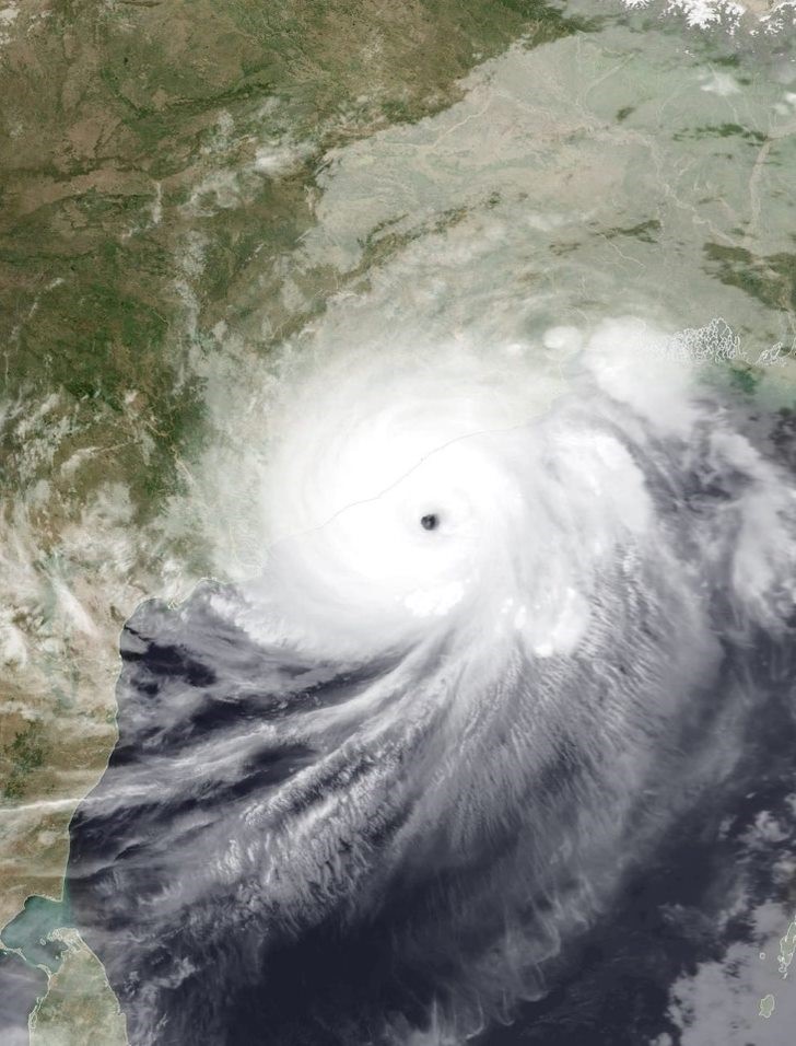
A tropical cyclone refers to an intense whirlwind with the lowest pressure at the centre. They generally emerge over warm tropical oceans and strike with strong gusts of wind, heavy rain and storm surge (tidal waves). The speed of wind ranges from 62-87 kmph for cyclonic storms, 88-117 kmph for severe cyclonic storms, 88-117 kmph for very severe cyclonic storms, 168-221 kmph for extremely severe cyclonic storms and above 222 kmph for super cyclonic storms. The speed of wind can even hit 320 kmph. These cyclonic storms, also known as typhoons or hurricanes, move around the cyclone centre in an anti-clockwise direction in the northern hemisphere, and clockwise direction in the southern hemisphere.
The damage that a cyclone can do depends not just on wind speeds, but also on the density of people living in vulnerable places (type of house and other infrastructure) as well as the accuracy of predictions with timely warnings to people, giving them an opportunity to evacuate before the cyclone hits. Science-based warning systems for storms have been evolving since the 1800s, more so in recent times since 1960s with the launch of satellites and radars. The nodal organisation responsible for weather forecasting in India is the India Meteorological Department (IMD). Though it was officially established in 1875, it had been exploring cyclone warning systems a few years earlier in 1868 with the first warning issued for Kolkata Port. The wakeup call came when two cyclonic storms from the Bay of Bengal struck India in 1864 – one near Calcutta (now Kolkata) and the other in Machilipatnam in today’s Andhra Pradesh. As a result, by 1898, all the ports in India had a uniform system of storm warning signals. Visakhapatnam was home to the first cyclone detection radar in 1970. The first Indian satellite – INSAT – for cyclone monitoring was successfully launched into orbit in 1983.
Despite this meteorological infrastructure, people living in and near the storm’s eye when Paradip cyclone struck did not have enough time to evacuate. Also, there was insufficient infrastructure like cyclone shelters and roads to evacuate people to safer places. People were predominantly living in mud and thatched houses. Fortunately, in the two decades since, India has made substantial progress in cyclone predictions.
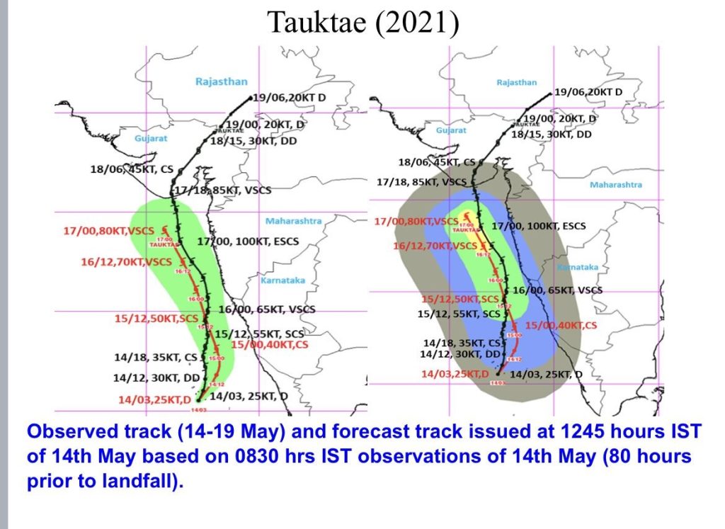
One of the steps taken by the Government of India was to establish the National Cyclone Risk Mitigation Project. “Phase 1 of it is already operational in the most cyclone-prone states of Andhra Pradesh and Odisha. West Bengal, Tamil Nadu, and west coast states including Kerala, Karnataka, Maharashtra and Gujarat fall in Phase 2 of the project, which has been implemented in 2022. [As part of this project], we are looking at developing infrastructure including more public alert systems, saline embankments and construction of plenty more cyclone shelters,” says GS Srinivas Reddy, Senior Consultant at Karnataka Disaster Management Authority.
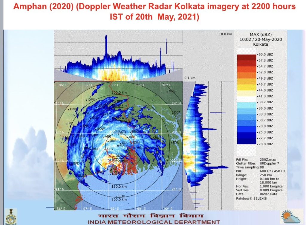
A significant tool in cyclone predictions is radar. India currently has 37 radars dedicated to weather forecasting (India was earlier using analog radars, but Doppler weather radars are now being used, and these are now manufactured by Indian companies). The country has 12 Doppler Weather Radars (DWR) along the coast. Dr KJ Ramesh, Former Director General, IMD, explains the significance of DWRs: “When a cyclone intensifies and moves in a direction approaching the coast, these DWRs capture its information within 300 to 500 km radius. The changes are captured every ten minutes. With this data, the physical characteristics are studied for cyclone monitoring.” Details of a cyclone’s radial velocity, spectral width, reflectivity and even surface rainfall intensity can be monitored with the help of these radars. However, the information is typically restricted to 250 km range when it comes to radial velocity and 150 km range with respect to rainfall intensity. The data from these radars are also assimilated in numerical models to provide short range forecasts.
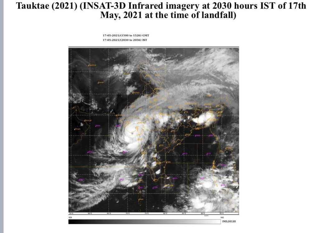
India also has two indigenous meteorological satellites – INSAT-3D and INSAT-3DR. “Satellite data are useful when cyclones are in their formative stage. When the cyclone is closer, data from satellites and radars play an important role in determining its location, intensity, water content, cloud depth, precipitation and wind distribution in terms of finding out which part of the cyclone will cover which area,” states Ramesh. Real-time data collection helps provide updates every 10 minutes. “Earlier, we used American satellites and geostationary satellites belonging to other foreign countries. Today, our satellites provide information to many countries in the world and radar outputs are shared with neighbouring countries,” says Director General of IMD Dr M Mohapatra. “When it comes to cyclone monitoring and prediction, we not only rely on our satellites, but we [also] collaborate with foreign satellites from the UK, US, Japan and more,” he adds.
For improving the accuracy of cyclone prediction and risk mitigation, several other technologies are also employed. For instance, India has observatories every 30 km along the coast, according to sources from the IMD. There are surface observatories, upper air observatories, glaciological observatories and more, which have eye-reading instruments, thermometers, anemometers, scatterometers and more for measuring parameters like temperature, pressure, wind speed, cloud, rain, lightning, and so on.
Ground data is collected through Automatic Weather Stations (AWS), which provide frequent readings, consume less power and can operate anywhere. “With 7500, Karnataka has the maximum number of Automatic Weather Stations in India. Maharashtra has 4000. Andhra Pradesh has 1800 to 2000 weather stations and rain gauges. Telangana is third with 900 to 1100,” says Ramesh.
Rahul Bedi, a weather enthusiast from Bengaluru, owns two private weather stations – one in the Whitefield area of the city and another in Coorg, Karnataka. “Almost every Panchayat in Karnataka has an Automated Weather Station set up by the government in addition to private weather stations. Data is shared through all these stations, some even open sourcing it. Weather, temperature and other such data are constantly read and observed with various instruments – some that are even home-built. Weather enthusiasts like me love observing this data to predict and forecast any likely weather changes or even disasters,” Bedi reveals.
Buoys – floating devices – too play a significant role in cyclone monitoring and detection. There are 20 buoys established both in Arabian Sea and Bay of Bengal, says Mohapatra. Buoys are platforms that come with sensors that can measure wind speed, temperature, air pressure, humidity and wave parameters.
By 2020, Geographic Information System (GIS) platforms were also in use for cyclone tracking and mapping.
Mohapatra points to another significant tool in predicting cyclones. “While we need all the hardware for measuring data, adequate software and various computing platforms are equally essential to analyse this data. There are various model technologies being utilised at the regional and global levels. There are seven different models running every day in the Ministry of Earth Sciences (MoES). Data is fed through various sources including the IMD and the analysis is customised for India.”
But technology is far from perfect. “Humans are involved in course correction. There are 29 forecasting offices countrywide. The scientists from these offices gather over video conference every morning to arrive at a consensus using technology, experience and a decision support system for the best estimation,” says Mohapatra. And based on these analyses, three bulletins are out by noon during cyclone period. Bulletins are otherwise issued twice a day during normal weather conditions.
Cyclone forecasts and predictions are only meaningful when this information is disseminated. “13 types of bulletins are issued daily during cyclone time for coastal as well as marine community. These bulletins are also issued in graphical format and over GIS platforms. These bulletins are specifically designed for various stakeholders as per their requirement. For example, port warnings are issued for affected ports and sea area warnings are issued for high-sea shipping. Some bulletins are tailored for fishermen and some for international civil aviation to help with air traffic,” adds Mohapatra. He says that region-specific bulletins are designed in terms of heavy rainfall, wind and storm surge over a region. The Web-based Dynamic Composite risk atlas (Web-DCRA) tool, developed by the National Disaster Management Authority (NDMA) in collaboration with IMD, MoES, state governments, is used for this purpose.
The public SMS system was introduced in 2014 for improving last mile connectivity, and the use of social media gained traction in 2015-2016.
The IMD prides itself in adapting to evolving technologies to help formulate more effective early cyclone forecast and warning, while mitigating disaster. Vulnerability analysis is also carried out in terms of impact-based forecast and risk-based warnings. IMD has upgraded its early warning system, communication, preparedness and other measures. It has come a long way in just a few years after the Paradip Super Cyclone. It has succeeded in ensuring that recent cyclones like Phailin, Hudhud or Fani did not cause the kind of havoc unleashed by cyclones like Bhola or Paradip. Its early warning helped minimise loss of human lives to single/double digits. IMD’s success has come about through a rigorous application of science and technology, along with the single-minded determination of meteorological researchers.
– Pratiba Raman